Zoom in far enough on any map and the world stops looking so orderly. A sliver of Michigan is completely surrounded by Ohio, a country tucked inside another country that’s tucked inside a third, and a town whose border doesn’t just exist on paper; it cuts straight through people’s living rooms.
None of it is a mapmaking mistake.
Every one of these strange international borders is real, the result of old treaties, wars, or plain surveying errors that residents still live with generations later.
Here’s a tour of some of the world’s weirdest borders and how they came to be.
#1 The Baarle-Hertog/Baarle-Nassau Border
Maps start to look like they have been tampered with when you zoom in on a corner of the southern Netherlands. Parts of both towns, Baarle-Hertog, a Belgian municipality, and Baarle-Nassau, a Dutch municipality, overlap to create this anomaly. Together, they contain 30 enclaves. 22 of these are pieces of Belgium surrounded by Dutch territory, 7 are small Dutch enclaves sitting within the Belgian pieces.
Basically, there is a small part of Belgium inside the Netherlands, and some of the Netherlands is inside that part of Belgium. On maps, this looks like a very messy jigsaw puzzle, and in real life, white crosses painted into roads and flags are used to identify which buildings belong to what country.
According to Discovering Belgium, the chaos has persisted since the Middle Ages, when complex territorial transfers were made between the Lords of Breda and the Dukes of Brabant. When Belgium gained its independence in 1830, and it became necessary to draw a clean line between the two towns, the border commission gave up trying.
The voordeurregel is one of the most interesting results of this border. It is a legal principle that dictates which country a split property belongs to by the location of its front door. Of course, owners of these kinds of properties can take advantage by moving their front doors to a country with more favorable tax rates or local services.
What makes Baarle unusually livable, compared to most of the other split towns on this list, is that both Belgium and the Netherlands are part of the European Union’s Schengen zone.
There’s no passport check, no customs stop, and no border patrol, just a change of country mid-stride through a Belgian bakery or a Dutch supermarket. It’s a reminder that even the most tangled international border can feel invisible once the countries on either side agree to open it.
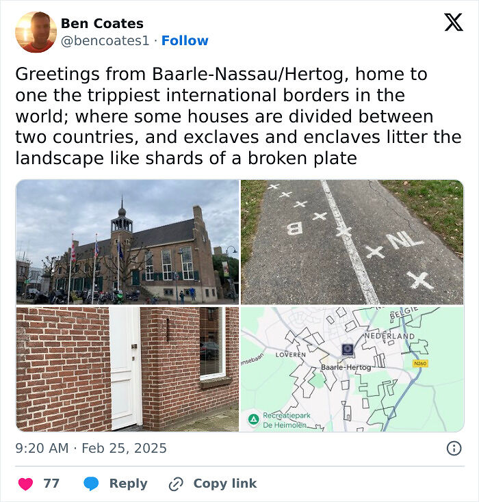
Image source: bencoates1

#2 The Caprivi Strip: Germany’s Border Blunder In Africa
Namibia has a streak in its northeast corner that you would probably miss if you’re not squinting or zoomed in. Stretching for about 450km, it looks like an accusing finger pointed at Zimbabwe.
This absurd shape on the map resulted from a major blunder by Germany, which left it with a corridor leading nowhere.
According to a New York Times report, in 1890 Germany (which controlled Namibia) sought a route to Tanzania and a highway across the Zambezi River. They traded their rights on Zanzibar for a strip of land with Britain, who gladly agreed.
Only after the trade did the Germans realize the route led nowhere. Victoria Falls, one of the world’s biggest waterfalls, and other waterfalls lined the road, making it impossible to navigate.
Germany’s colonial planners had drawn one of the strangest borders in Africa without ever checking the terrain.
Today, the Caprivi Strip is a great safari destination, as seen on Safari Online, with its landscape home to elephants, hippos, and birds of various species, drawing steady travel interest from visitors who want to see the corridor Germany never got to use.
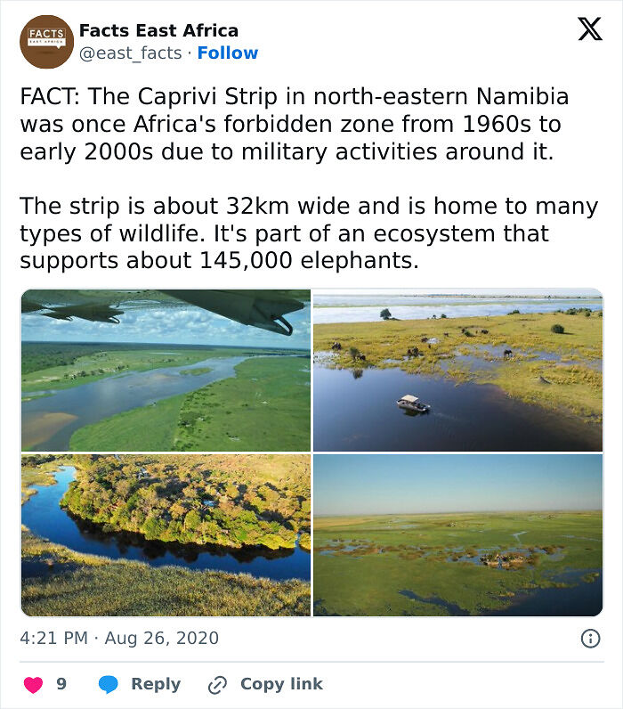
Image source: east_facts
#3 Nahwa-Madha: A Country Inside A Country Inside A Country
The countries, the United Arab Emirates and Oman, are in a border situation similar to that in Baarle. Inside the UAE is a piece of another country, Oman, called Madha, and inside that is another piece of the UAE called Nahwa. This means Nahwa, a counter-enclave inside an enclave, inside a country, kinda like a donut ring.
The origin of this geographical donut lies in the people of Madha swearing allegiance to the rulers of Oman, except for the village of Nahwa. Bayut reports that in 1969, the British Council, after years of trying, finally succeeded in drawing defined borders between all parties.
Today, according to Young Pioneer Tours, crossing between all three jurisdictions doesn’t even need a stamp or passport check. You can confirm that you’ve crossed into a different territory with paved roads and flags planted everywhere.
Ask anyone who has actually made the drive, and they’ll tell you Nahwa is less a border crossing and more a strange kind of city-hopping: three separate territories, one uninterrupted stretch of road.
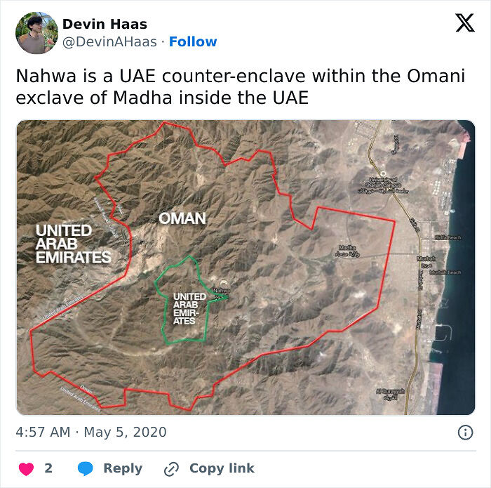
Image source: devinahaas
#4 Pheasant Island: The Border That Switches Countries Twice A Year
Not to burst your bubble, but there aren’t any pheasants on this island. It has something even more interesting: alternating ownership between countries throughout the year. The island lies between France and Spain and sits on the Bidasoa River.
While condominiums like this are not unusual in international law, Pheasant Island is the only one that changes ownership mid-year rather than being owned simultaneously.
Under the terms of the agreement, the island belongs to Spain from February 1 to July 31, and then flips to France from August 1 to January 31st.
According to the BBC, Pheasant Island is the result of bad blood between France and Spain that persisted even after the European Thirty Years’ War ended in 1648.
After a series of summits on the Island as neutral ground to reach an understanding, the Treaty of the Pyrenees was signed in 1960. Now, every 6 months, both countries meet to sign paperwork and hand over the territory as a symbol of peace.
If you’ve got plans to visit Pheasant Island soon, you might want to check your calendar to see whether it’ll be in Spanish or French that day. It’s not set up for tourist travel either way, so most people only see this odd little European border from the riverbank.
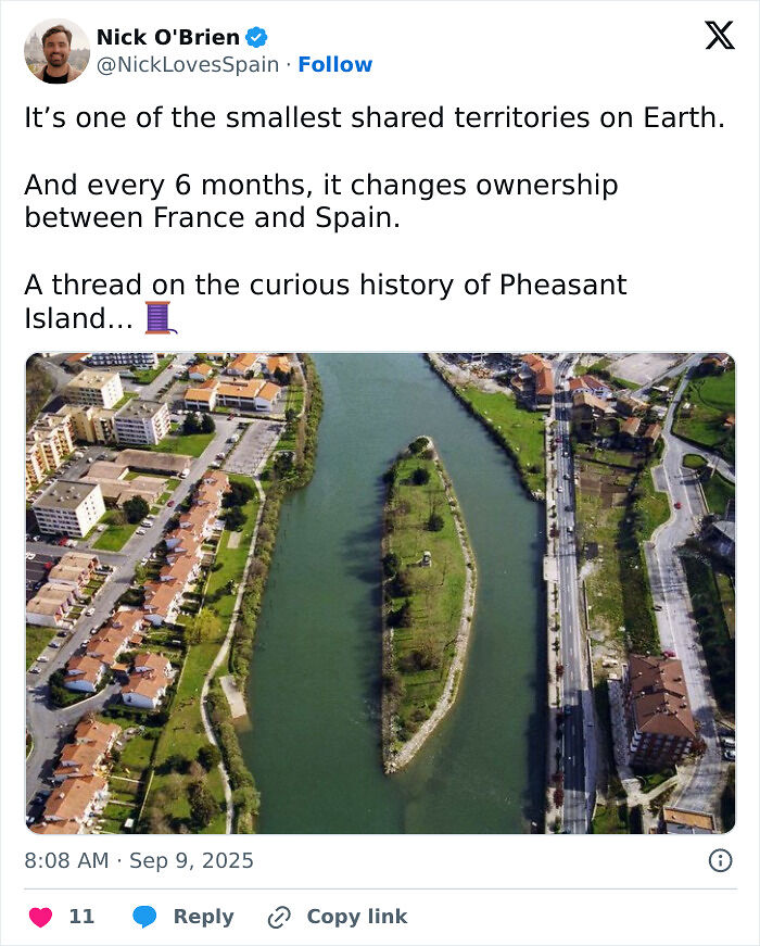
Image source: nicklovesspain
#5 Bir Tawil: The Land No Country Wants
Rather than being a piece of land fought over by multiple countries, the Bir Twail is uninhabited and also unclaimed by any state.
This 2060-square-kilometer area is located in the Sahara Desert and is owned by neither Egypt nor Sudan, which surround it. It is also called the Bir Tawi Triangle, together with the Halaib Triangle, an important part of the origin story.
The reason for this unusual spot on the world map is, simply put, diplomacy. In 1899, a map was drawn along the 22nd parallel that put Bir Tawil with Sudan and the Halaib Triangle with Egypt.
Then, in 1902, another map was drawn up with a border line that flipped the territories between the two countries.
Both wanted the Halaib Triangle because it had greater potential for mineral resources and economic value. Since they could each claim only one territory, and claiming Bir Tawil would mean surrendering the rich Halaib, they both simply looked away and left it unclaimed.
While the Halaib Triangle is still disputed, as Sudan also claims it, it is currently Egypt’s territory. Bir Tawil, on the other hand, has attracted a number of people who have tried to claim the land for themselves.
Young Pioneer Tours reports that a popular one occurred in 2014, when Jeremiah Heaton tried to claim the area, naming it “The Kingdom of North Sudan”. Apparently, it was an attempt to fulfill his daughter’s wish to be a “real-life princess”.
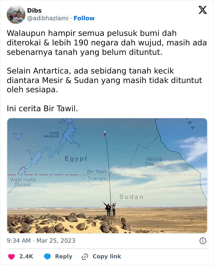
Image source: adibhazlami
#6 Point Roberts: The Us Border Town You Can Only Reach Through Canada
The five square miles of Point Roberts are surrounded by water to the east, west, and south.
To the North, though, it borders Canada. So, this small town in America can only be reached by going through Canada. To get anywhere in America, residents also have to cross into Canada through British Columbia and then back into the U.S.
After an agreement in 1846 to extend the 49th parallel as the border between the US and Canada, no one noticed that a small area would fall below that line. Geographically, Point Roberts is attached to Canada, but politically, it belongs to Washington state.
While Little America, a nickname for Point Roberts, is a fascinating place, its residents bear the consequences of this historical mistake.
According to The Bellingham Herald, during the COVID-19 pandemic, the US and Canada closed their borders and cut off water travel. This meant that despite being an American town, residents couldn’t reach the rest of their own country.
A Border Task Force had to be established to meet citizens’ needs during that time. Even now, something as routine as a grocery run means clearing a border checkpoint twice, a daily reality most towns never have to think about.
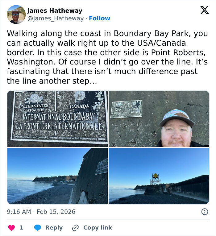
Image source: james_hatheway
#7 The Wakhan Corridor: Afghanistan’s Border Buffer With China
On the world map, Afghanistan appears to have an extending tail called the Wakhan Corridor. That Afghan territory is bordered by Tajikistan and Pakistan, and eventually reaches China at the tip. The narrow Wakhan Corridor is as thin as 13km in some places, but is an important piece of history.
Central Asia: Historical Geography II reports that the Corridor was a solution to a long political conflict between the British and Russian empires in the 19th century.
Both decided that expanding territories should not share a border; instead, Afghanistan and China should border each other. So, a strip of Afghan land was drawn between Pakistan and Tajikistan, and borders were formally set.
With the borders set, the Wakhi people were inevitably divided among the inhabitants of three different countries. Today, about 18,000 people live in the Wakhan Corridor, and Tolo News reports their complaints about the lack of basic life services in the district.
Where Afghanistan, Pakistan, Tajikistan, and China nearly meet at the corridor’s tip, the region comes close to forming a rare tripoint, one of those spots on Earth where borders converge from every direction at once.
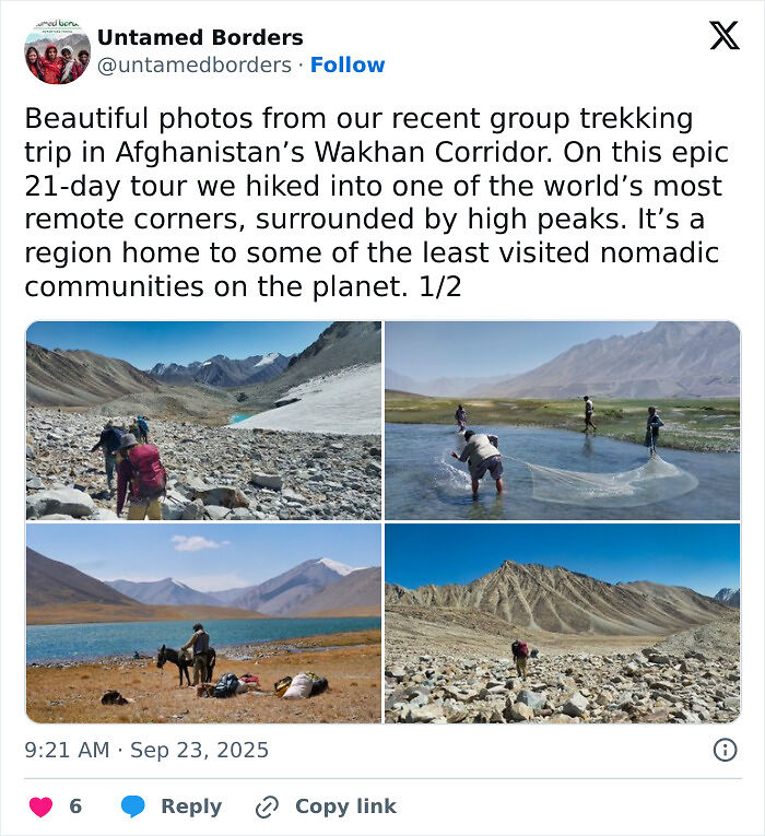
Image source: untamedborders
#8 The Diomede Islands: A Us-Russia Border In The Middle Of The Sea
The Diomede Islands are two tiny islands separated by only about four kilometers, but are under the jurisdiction of the USA and Russia, respectively. Interestingly, these islands are also in two different time zones.
This is because the International Date Line, dividing the South and North poles, runs between them in the middle of the Bering Strait. Now, Big Diomede is about 21 hours ahead of Little Diomede.
Big Diomede, also called Tomorrow Island, is on Russia’s side of the border, while Little Diomede is in the U.S. in Alaska.
According to PBS, during World War II, Big Diomede was a Russian military base, and so all residents were moved to mainland Russia. The community between the two islands was broken, and the Soviets imposed restrictions on crossing to their island.
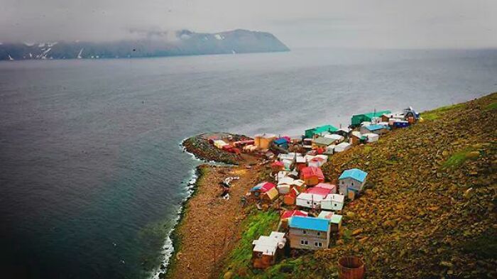
Image source: reddit.com
#9 Derby Line: The Us-Canada Border That Runs Through A Library
The international border between Derby Line, Vermont, and Stanstead, Quebec, runs through streets, houses, and most interestingly, a public library.
It goes right down the middle of a main road called Canusa Avenue, making it one of the few places in the world where you can stand in two different countries at once.
The Haskell Free Library and Opera House was deliberately built right on the border in 1904 as a symbol of goodwill between the US and Canada.
It has addresses in both Quebec and Vermont, with a thick black line on the floor to demarcate the two countries. You can sit with your feet in Canada and the rest of your body in the United States.
During Trump’s first administration as President of the US, the travel bans restricted people living in the US with single-entry visas from leaving.
Families were separated, and during that time, The Connecticut Public reported that the Haskell Free Library was a space for families to reunite for a while. It remains one of the only towns on Earth where the line between two countries runs straight through a bookshelf.
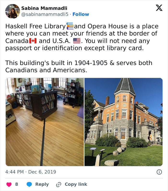
Image source: sabinamammadli5
#10 The India-Bangladesh Border Maze
As twisted as Baarle-Hertog might be, the enclave situation between India and Bangladesh is more complex and more tragic.
When modern India was created in 1947 and Bangladesh in 1971, many enclaves were scattered across the border, inside each other.
111 Indian enclaves were within Bangladesh, and 51 Bangladeshi enclaves were within India. One peculiar one is the Dahala Khagrabari, the world’s only third-order enclave.
It is a Bangladeshi enclave within an Indian enclave, within a Bangladeshi enclave, within India. As fascinating as it sounds, it was chaos for residents.
Living without citizenship meant they couldn’t legally cross into the surrounding country to access schools or hospitals.
According to the BBC, it was not until 2015 that both countries decided to exchange enclaves. About 50,000 residents were given the option to choose their favorite country to live in and were granted citizenship.
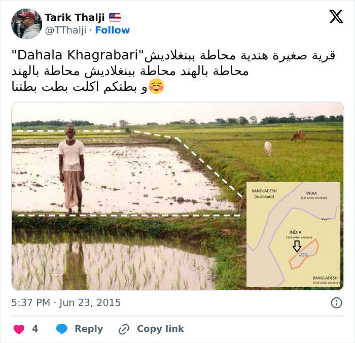
Image source: tthalji
Summary:
What is the weirdest border in the world?
There’s no single official answer, but Baarle-Hertog/Baarle-Nassau on the Belgium-Netherlands border is the example most travel writers and geographers point to first, thanks to its 30 tangled enclaves.
Nahwa-Madha on the UAE-Oman border is a close second for sheer geographic absurdity, a country inside a country inside a country.
What state has the weirdest borders?
Kentucky has the weirdest border in the US, with the famous “Kentucky Bend” a standout feature on the state’s map.
What is the most complicated border in the world?
The Baarle-Hertog/Baarle-Nassau border is the most complex border still in existence. There are 30 intertwined enclaves between the countries.
What is the weirdest-shaped US state?
Michigan is the weirdest-shaped state in the US because it is split into two large peninsulas and surrounded by the Great Lakes.
It’s said to be shaped like a right mitten.
 Follow Us